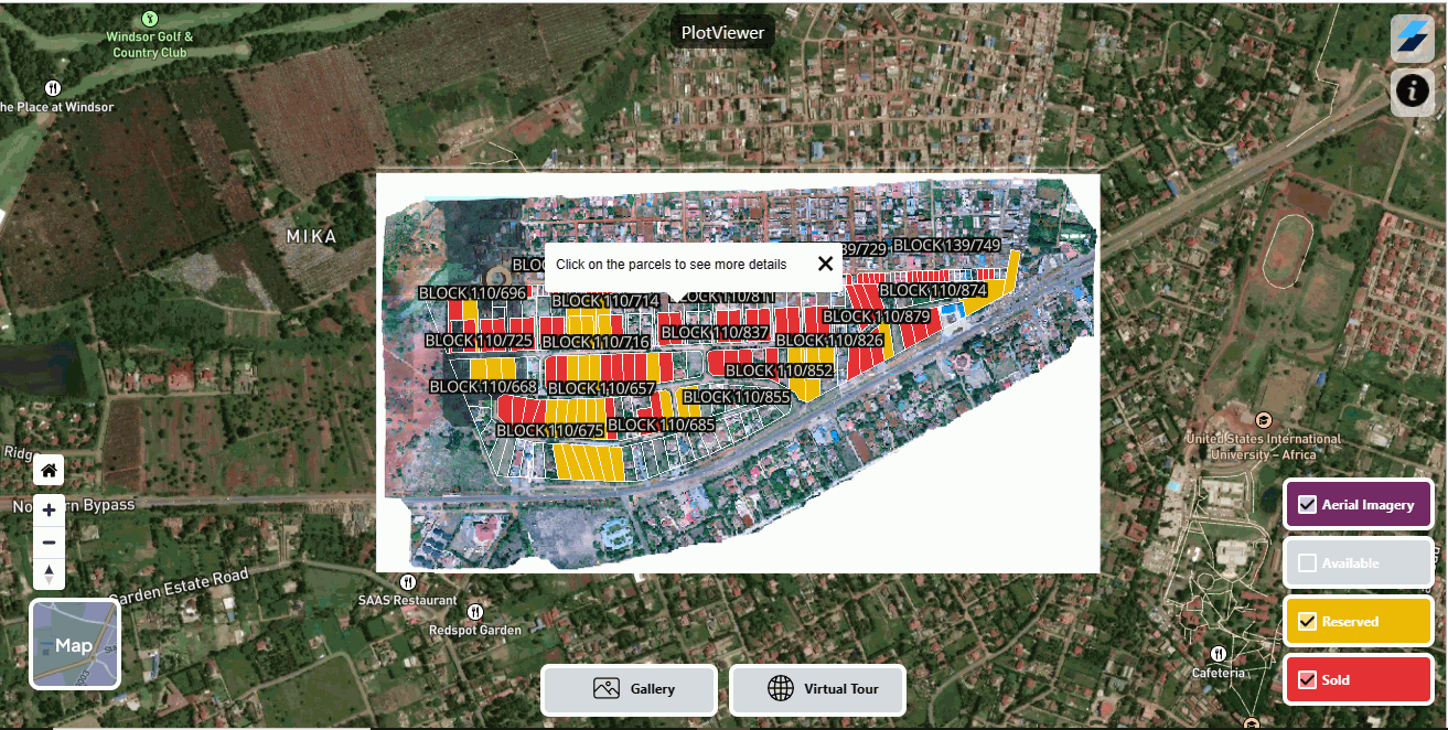
AerialGis
AerialGIS is a dynamic platform that revolutionizes the real estate industry. With the power of Web GIS technologies, it offers an intuitive interface to access
Manage your electricity networks, streamline asset management, and analyze energy distribution with ease.
At Jugrafiya, we specialize in delivering advanced geospatial solutions for the Electric Utility sector, empowering companies to plan, manage, monitor, and modernize their networks with precision and intelligence.
Whether you’re migrating from legacy Geometric Networks to the modern Utility Network model, building intuitive dashboards for field crews, or integrating complex asset data into your enterprise systems — our team has done it all.
We help electric utility companies:
Digitize and modernize their entire utility infrastructure
Model and manage electrical networks using ArcGIS Utility Network and ArcGIS Pro
Build real-time dashboards and custom web apps for operations, outage response, and asset tracking
Develop field-ready applications to streamline inspections, repairs, and meter reading
Enable data-driven decision making through advanced analytics and reporting tools
We leverage a wide range of cutting-edge technologies and tools tailored for electric utility projects:
ArcGIS Utility Network
Model electric distribution, transmission, substations, and services with advanced tracing, network topology, and connectivity rules.
ArcGIS Geometric Network
For clients on legacy systems, we provide support, maintenance, and transition planning.
ArcGIS Pro Add-ins
Custom tools for planners, engineers, and analysts to automate workflows, enhance productivity, and perform advanced analysis inside ArcGIS Pro.
ArcGIS Experience Builder
Build immersive, responsive web applications for asset monitoring, fault detection, and crew management — tailored for both internal teams and the public.
ArcGIS Web AppBuilder
Create powerful map-based applications with custom widgets for electric utility use cases.
ArcGIS Field Maps & Survey123
Enable mobile crews to inspect assets, report incidents, and collect field data in real-time.
PostgreSQL/PostGIS
Enterprise geospatial database support for high-performance querying and spatial joins.
Microsoft SQL Server with Esri SDE
Robust backend support for large utility datasets and integrations with other enterprise tools.
FME (Feature Manipulation Engine)
Data transformation pipelines between CAD, SCADA, GIS, and tabular sources.
Python & ArcPy
Workflow automation, validation scripts, and batch processing tasks.
REST APIs & GeoServices
Integration with ERP systems, SCADA, CRM, or outage management systems.
Outage Management Visualization
Real-time dashboards showing fault locations, estimated restoration time, and impacted customers.
Load Flow Analysis
Spatial modeling of electric flow paths for planning and maintenance using ArcGIS Utility Network.
Substation & Pole Management
Asset-level visualization, inspection history, and maintenance scheduling.
Network Migration
Geometric Network to Utility Network migration with topology validation, rule enforcement, and training.
Public-Facing Web Portals
Inform citizens about planned outages, ongoing maintenance, and contact points.
Deep expertise in GIS for Electric Utilities
End-to-end project ownership — from data preparation to deployment and training
Proven experience with ArcGIS Enterprise, Pro, Online, and the latest Esri APIs
Agile teams that collaborate closely with your utility engineers and IT staff
Emphasis on accuracy, uptime, and compliance
Looking to modernize your electric network? Let’s talk.
At Jugrafiya, we bring data, design, and technology together to illuminate the path forward for utility providers across the globe.
AerialGIS is a dynamic platform that revolutionizes the real estate industry. With the power of Web GIS technologies, it offers an intuitive interface to access
Have a question, project idea, or need support? We’re here to help. Reach out to our team, and we’ll get back to you as soon as possible.