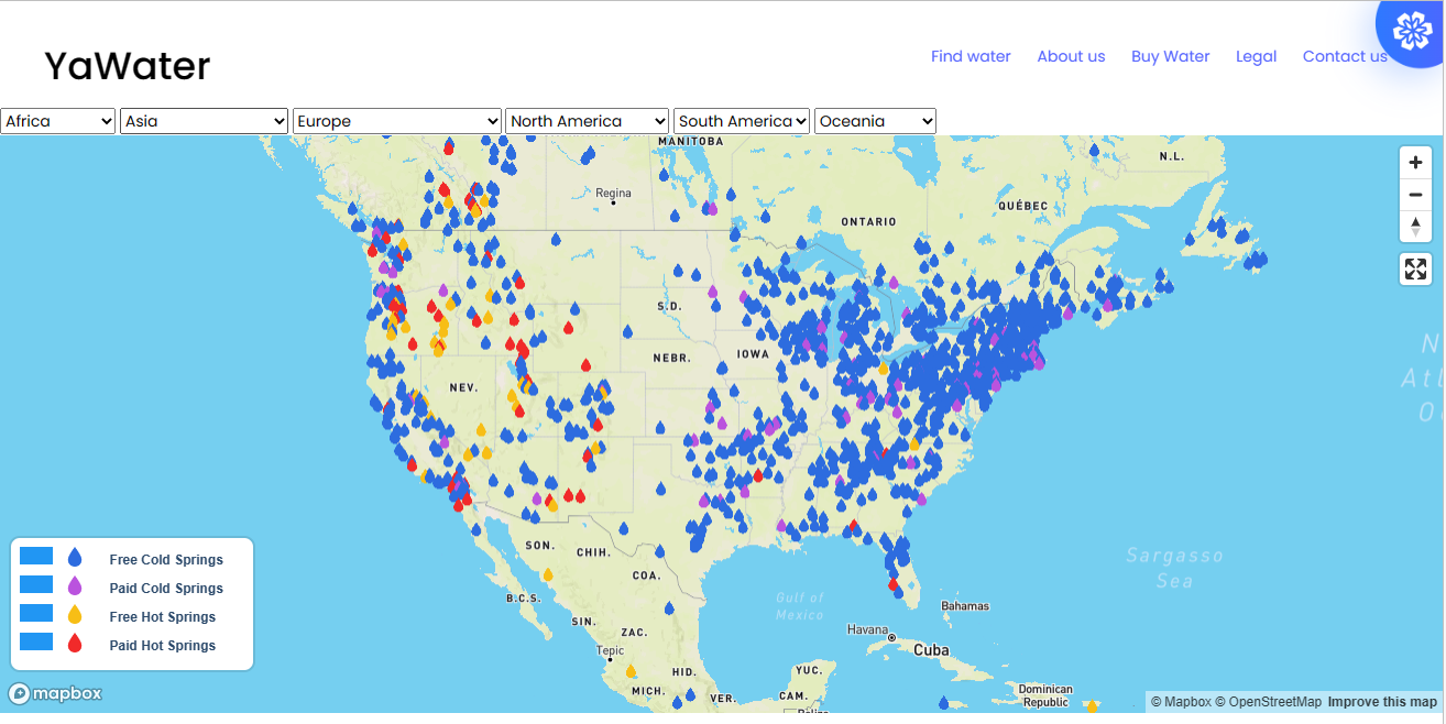
Yawater
This web app was created to inform people about the existence of powerful water sources on our planet that can greatly benefit the human body.
Enhance the visitor experience, and plan your tourism marketing with interactive maps and location-based services.
Tourism thrives on discovery — and discovery begins with maps. At Jugrafiya, we help tourism boards, cultural organizations, and private operators harness the power of geospatial technology to promote destinations, enhance visitor experiences, and drive sustainable tourism development.
Whether you’re creating a digital tourism portal, mapping heritage trails, or managing ecotourism zones, our solutions connect travelers, planners, and decision-makers through interactive and insightful mapping tools.
We work with government and private tourism bodies to:
Build interactive tourist maps with attractions, routes, accommodations, and services
Create mobile-friendly travel portals with rich media, search, and filters
Map and manage heritage sites, cultural landmarks, and conservation areas
Enable event and festival mapping to drive seasonal tourism
Support eco-tourism, hiking, and trail navigation with route planning and safety features
Provide spatial analytics for tourism trends, footfall patterns, and regional promotion strategies
We specialize in scalable, open-source tools to help you reach travelers anywhere — with fast, interactive, and cost-effective mapping platforms:
Mapbox GL JS / MapLibre
Sleek and responsive maps that enhance the visual appeal of tourism apps and portals.
Leaflet.js
Lightweight and easily customized maps for tourist guides, park maps, and mobile experiences.
OpenLayers
For advanced mapping scenarios like route tracking, time-based animations, and multi-layer visualization.
GeoServer
Manage spatial datasets like heritage zones, national parks, protected areas, and travel routes via open GIS standards.
PostGIS (with PostgreSQL)
Analyze distances to attractions, optimize routes, and filter experiences based on location and region.
QGIS
Design print-ready maps, analyze trail networks, and plan development zones for tourism enhancement.
Python (Django / Flask / FastAPI)
Power custom APIs to support filters like “near me,” “top-rated,” or “open today.”
Turf.js
Perform real-time client-side geospatial calculations (e.g., nearest point of interest, buffer zones).
Digital Tourism Portals
Web platforms showcasing destinations, cultural sites, events, and visitor services with integrated maps and search tools.
Interactive Experience Maps
Theme-based maps (heritage walks, food trails, adventure zones, religious tourism) with media galleries, 360° views, and directions.
Route Mapping & Trail Navigation
Hiking, biking, and driving route maps with safety markers, difficulty levels, and GPS-based directions.
Smart Destination Dashboards
Analytics tools for tourism authorities to monitor trends, popular sites, visitor flow, and tourism impact.
Public Engagement Tools
Allow visitors to share experiences, suggest hidden spots, and report site conditions via crowdsourced data collection.
Expertise in building open-source, tourism-focused GIS applications
Experience working with cultural, historical, and environmental data
Mobile-first design approach tailored for travelers on the go
Custom-built solutions for both public awareness and internal management
Scalable, fast-loading maps — with or without internet access
Whether you’re promoting a hidden valley, planning a regional tourism campaign, or developing a visitor dashboard — Jugrafiya helps you turn maps into unforgettable journeys.
This web app was created to inform people about the existence of powerful water sources on our planet that can greatly benefit the human body.
Have a question, project idea, or need support? We’re here to help. Reach out to our team, and we’ll get back to you as soon as possible.