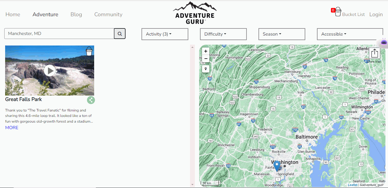
Adventure Guru
Adventure Guru is a inclusive video-based adventure guide that aims to address the diversity problem in outdoor recreation. Unlike other outlets that cater to a
Optimize crop management, yield and soil analysis, land use planning, and resource management.
Modern agriculture demands smarter decisions — guided by data, geography, and sustainability. At Jugrafiya, we help governments, agribusinesses, and NGOs harness the power of geospatial technology to transform traditional farming into data-driven agriculture.
From crop monitoring to irrigation planning, our GIS-based solutions help stakeholders optimize resources, improve yields, and monitor land at scale — sustainably and intelligently.
We work across the agricultural value chain to:
Map and monitor farmlands, crop zones, and irrigation networks
Deliver real-time dashboards for farm performance, weather, and vegetation indices
Enable remote sensing-based crop health analysis using NDVI, EVI, and more
Build field data collection apps for agronomists, field officers, and cooperatives
Support climate-resilient agriculture through spatial risk analysis and modeling
Provide AI-assisted predictions for crop yields, pests, and productivity
Our solutions are built on robust, open-source geospatial tools integrated with modern data science frameworks:
Mapbox GL JS / Leaflet.js / MapLibre
Build high-performance agricultural maps for field users and analysts.
QGIS
For geospatial planning, farm boundary digitization, and offline data analysis.
GeoServer
Serve crop zones, irrigation maps, soil data, and satellite layers via OGC standards (WMS/WFS).
PostGIS + PostgreSQL
Store and process large volumes of geospatial farm data, perform spatial joins, buffers, and zonal statistics.
Google Earth Engine (GEE)
Analyze satellite imagery (Sentinel, MODIS, Landsat) for crop monitoring, drought detection, and land use change.
Turf.js
For real-time spatial calculations in browser apps.
Python / NumPy / Pandas / Rasterio
For building AI/ML models and processing remote sensing data.
OpenCV + Deep Learning
Detect crop patterns, disease signatures, or invasive weeds from aerial imagery.
Farm Mapping & Plot Digitization
Create detailed farm maps with boundaries, crop types, ownership data, and seasonal attributes.
Crop Health Monitoring
Monitor vegetation trends with NDVI, identify stressed zones, and prioritize field visits.
Soil & Irrigation Analysis
Spatial mapping of soil quality, water availability, and irrigation networks for optimal input planning.
Field Data Collection Apps
Mobile tools for surveys, crop reporting, yield estimation, and damage assessments.
Agriculture Dashboards
Visualize crop distribution, risk zones, rainfall patterns, and advisory services in one place.
Climate & Pest Risk Modeling
Predict vulnerable regions for pests, droughts, or flooding using spatial overlays and historic patterns.
Practical experience in agriculture-focused GIS projects
Expertise in remote sensing, field data, and AI integration
Deep knowledge of open-source and cloud-based satellite platforms
Solutions tailored to local contexts, smallholder needs, and national programs
Agile delivery with on-ground collaboration when needed
Whether you’re mapping millions of farms or monitoring one season’s crop health — Jugrafiya brings data, geography, and technology together to grow more with less.
Adventure Guru is a inclusive video-based adventure guide that aims to address the diversity problem in outdoor recreation. Unlike other outlets that cater to a
Have a question, project idea, or need support? We’re here to help. Reach out to our team, and we’ll get back to you as soon as possible.